Mediums of Speculation: Seoul

Yukjo Street / Gwanghwamun Corridor, Seoul, South Korea — 1395 to present


PART I
STATEMENT

I have been inherited the space I live in.
I turn the faucet on,
Ride the train,
and live in buildings without knowing how they work.
My neighbors come from places I've never been to.
Life goes on.

Each of us
Lives in a different city
Collective memories and contributions
Expand, replace, and continue
The city breathes in and out,
Embedded cultural bones.

Blood flows in the city;
It swells, bloats, and rots.
Blood flows in the city;
It blooms, stretches, and grows.

Where I stand today was a different place.
My home will be someone else's.
Even when I'm gone, the city changes
And the memory of what was once there
Continues to refresh itself in our minds.
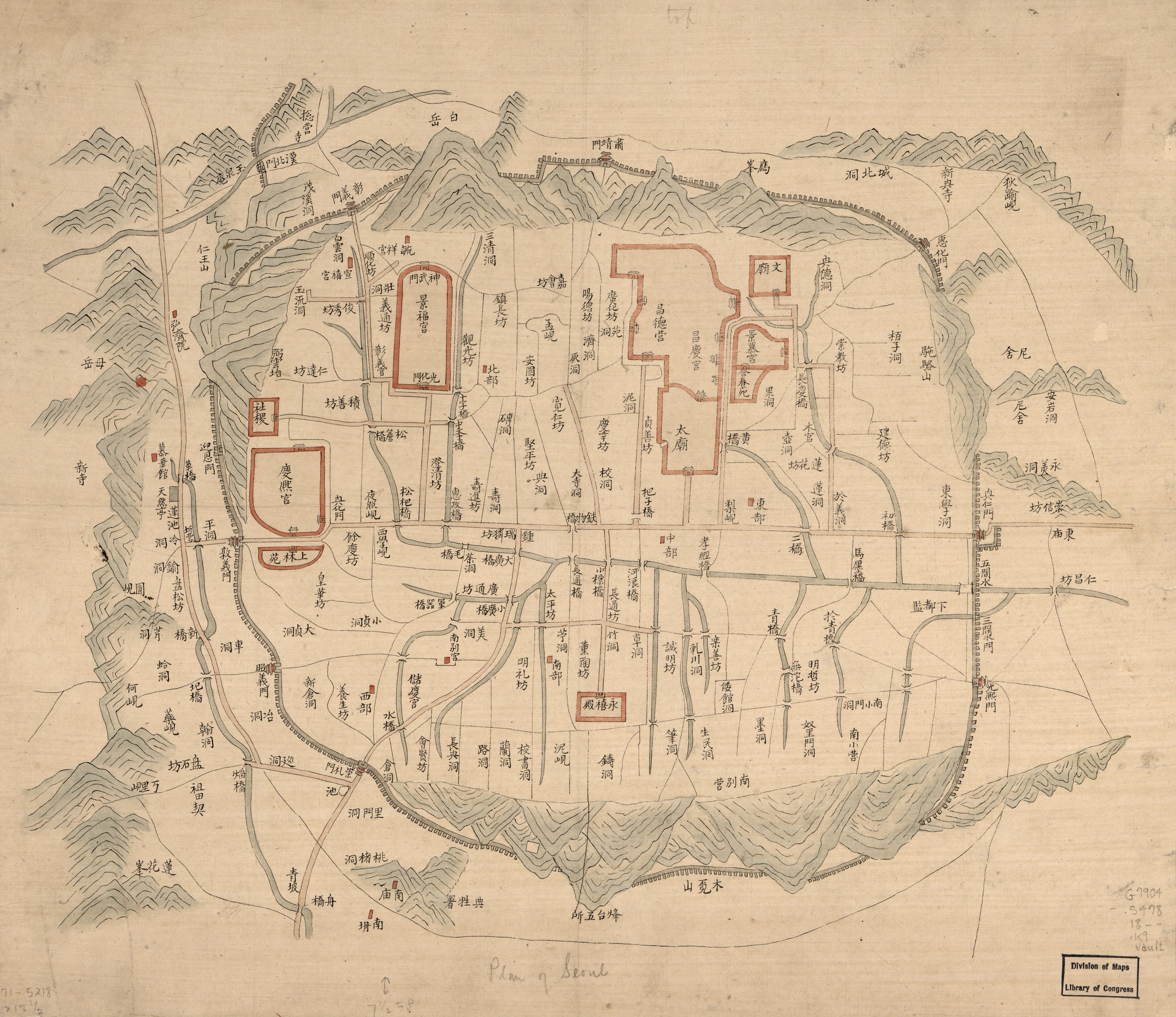
Before the Street
Hanyang before
the Joseon capital

Before 1394, the site was peripheral farmland at the foot of Bugaksan mountain, within the old Hanyang-bu county. The Goryeo Dynasty (918–1392) ruled from Kaesong to the north. When Yi Seong-gye founded the Joseon Dynasty in 1392, the geomancer Muhak and the neo-Confucian scholar Jeong Do-jeon debated the placement of the new capital. Jeong Do-jeon won: the main palace, Gyeongbokgung, would face south according to the Zhou Li principle, with Bugaksan as its backing mountain.

Jeong Do-jeon personally planned the capital's street system in 1395. He named each office along the main southern avenue: Yukjo-geori, the “Street of Six Ministries” — Ijo (Personnel), Hojo (Revenue), Yejo (Rites), Byeongjo (Military), Hyeongjo (Justice), and Gongjo (Works). The Uijeongbu (State Council) anchored the northern end near the gate. The Saheonbu (Office of the Inspector-General) and Hanseongbu (Seoul Prefecture) occupied the west side. The street was not merely administrative — it was a spatial argument for neo-Confucian governance, each ministry placed in a cosmologically prescribed position.

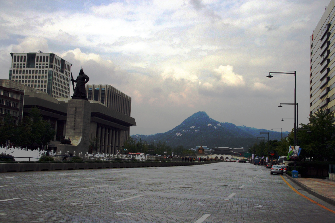
This arrangement persisted essentially unchanged for over five centuries. The street was narrow — perhaps 10 meters wide — with low wooden buildings, tile roofs, and open sky above. Bugaksan was visible from every point along its length.

The Project
Gwanghwamun Corridor
600 meters, 600 years

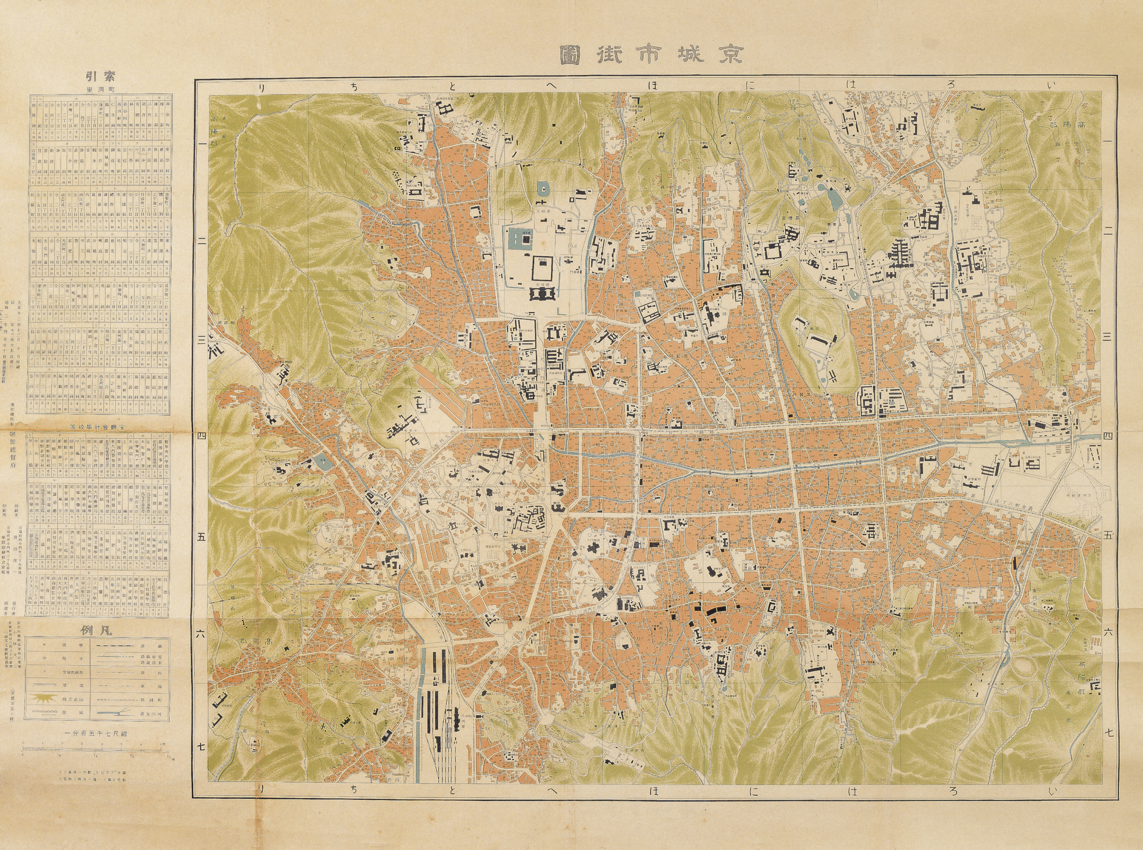
An artistic representation of how a specific area in a city was perceived differently over time — replanned, adjusted, and altered based on regime changes, policy, and cultural shifts. The target is a ~600m stretch of present-day Sejong-daero from Gwanghwamun Gate south to the Sejong-ro intersection: a place that was an urban center from the Joseon Dynasty, through Japanese Occupation, through the Korean War, through urban renewal, to today.

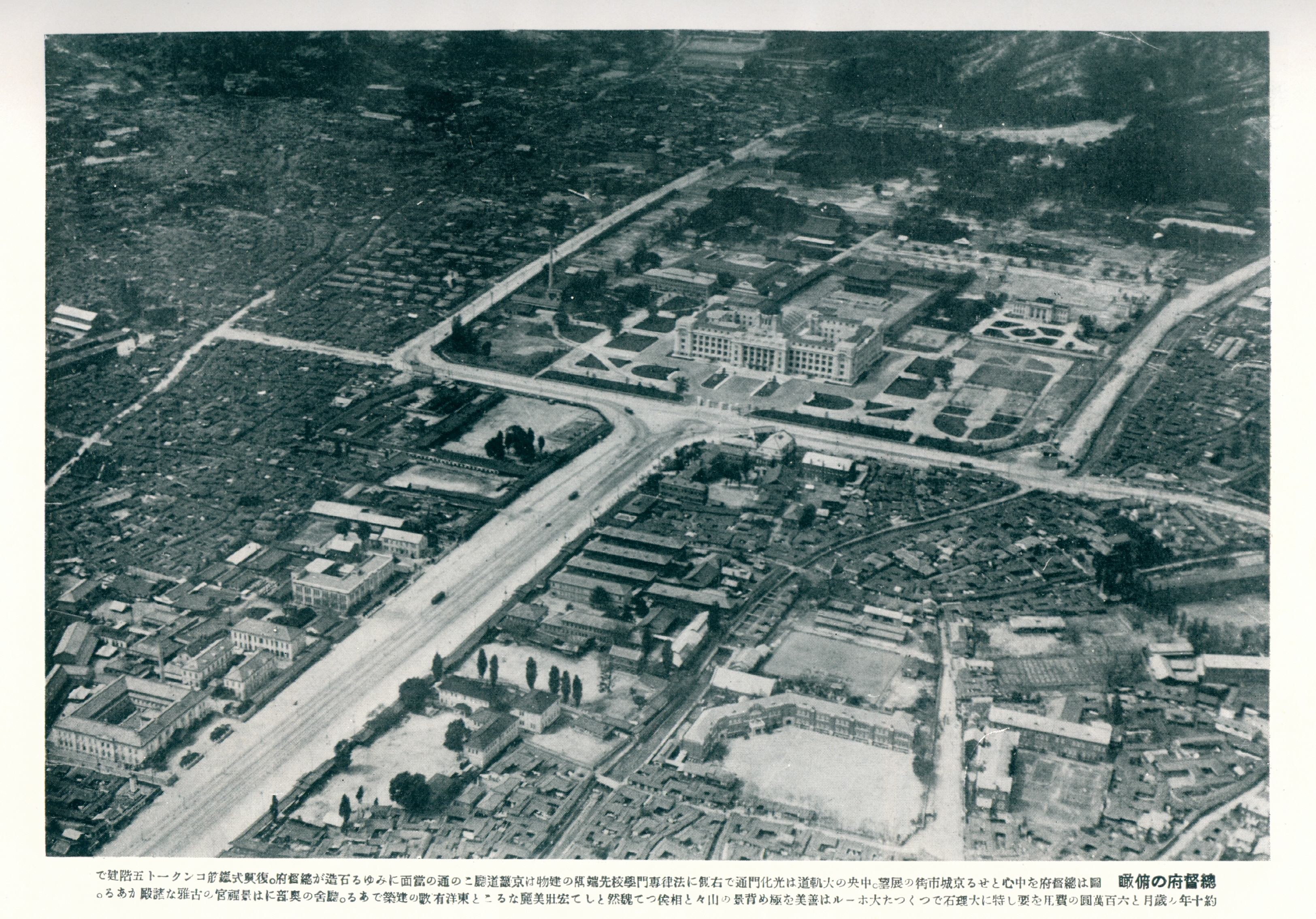
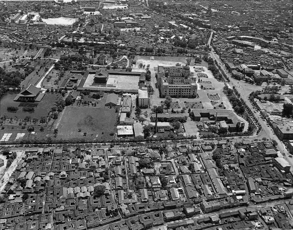
No other block in Seoul has this density of documented, layered transformation. This is literally a site where you can see through the archaeological layers — Joseon government offices buried under a Japanese colonial grid, covered by a post-war highway, now partially re-excavated. The sky-to-building ratio has undergone extreme transformation: from low wooden structures with open sky, to massive colonial edifice, to highway canyon, to partially reopened public square.


PART II
TIMELINE
EraWhat Stood Here
1395 — 1910Yukjo Street (“Street of Six Ministries”) — Uijeongbu, the six ministries, Saheonbu, Hanseongbu. Narrow traditional street, wooden government buildings, open sky.
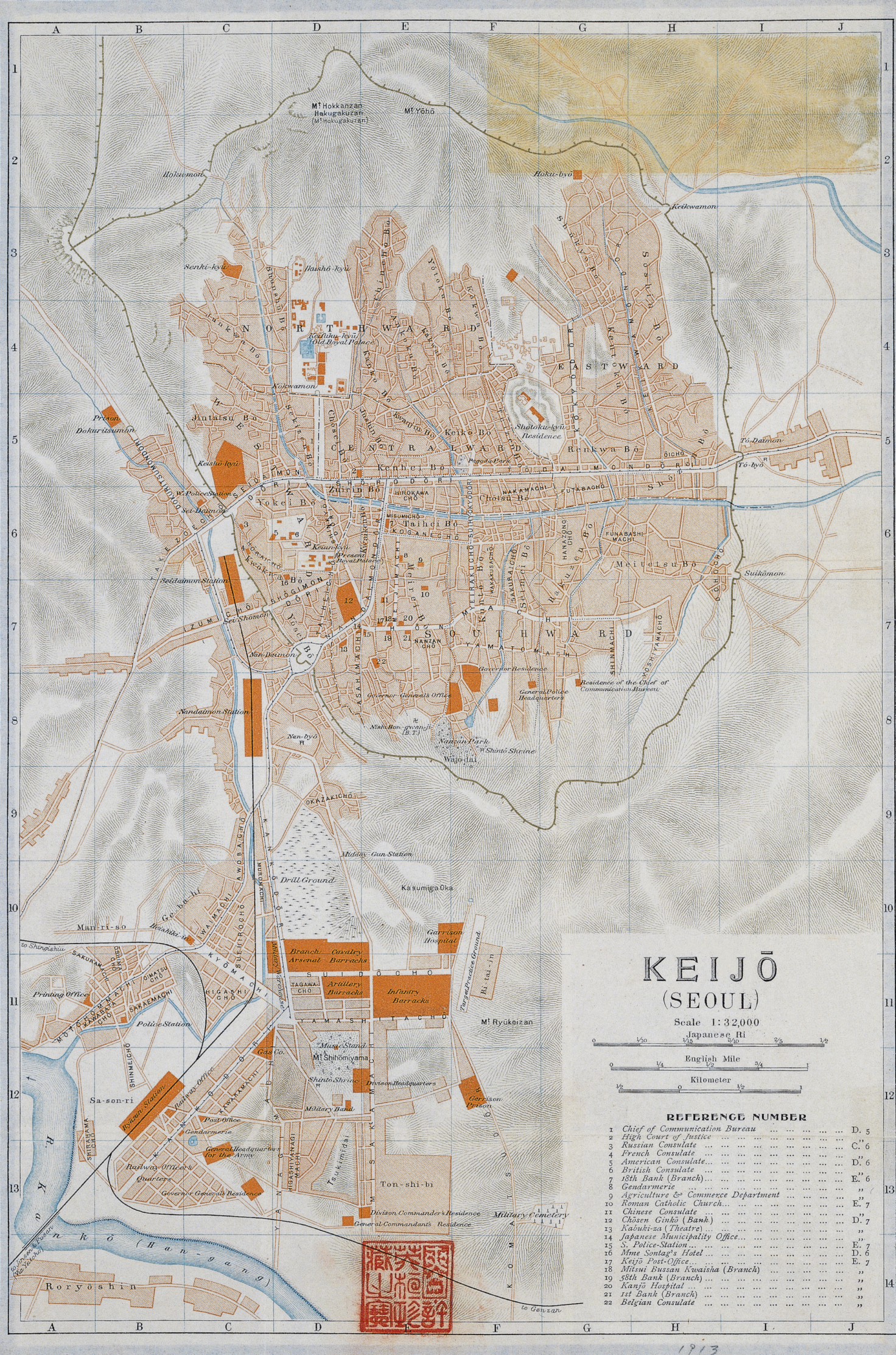
1912 — 1945Joseon buildings demolished. Street widened to 62m as Taihei Boulevard with tram tracks. Government-General Building (largest in East Asia) constructed 1916–1926, blocking Gyeongbokgung. Gwanghwamun Gate relocated east.
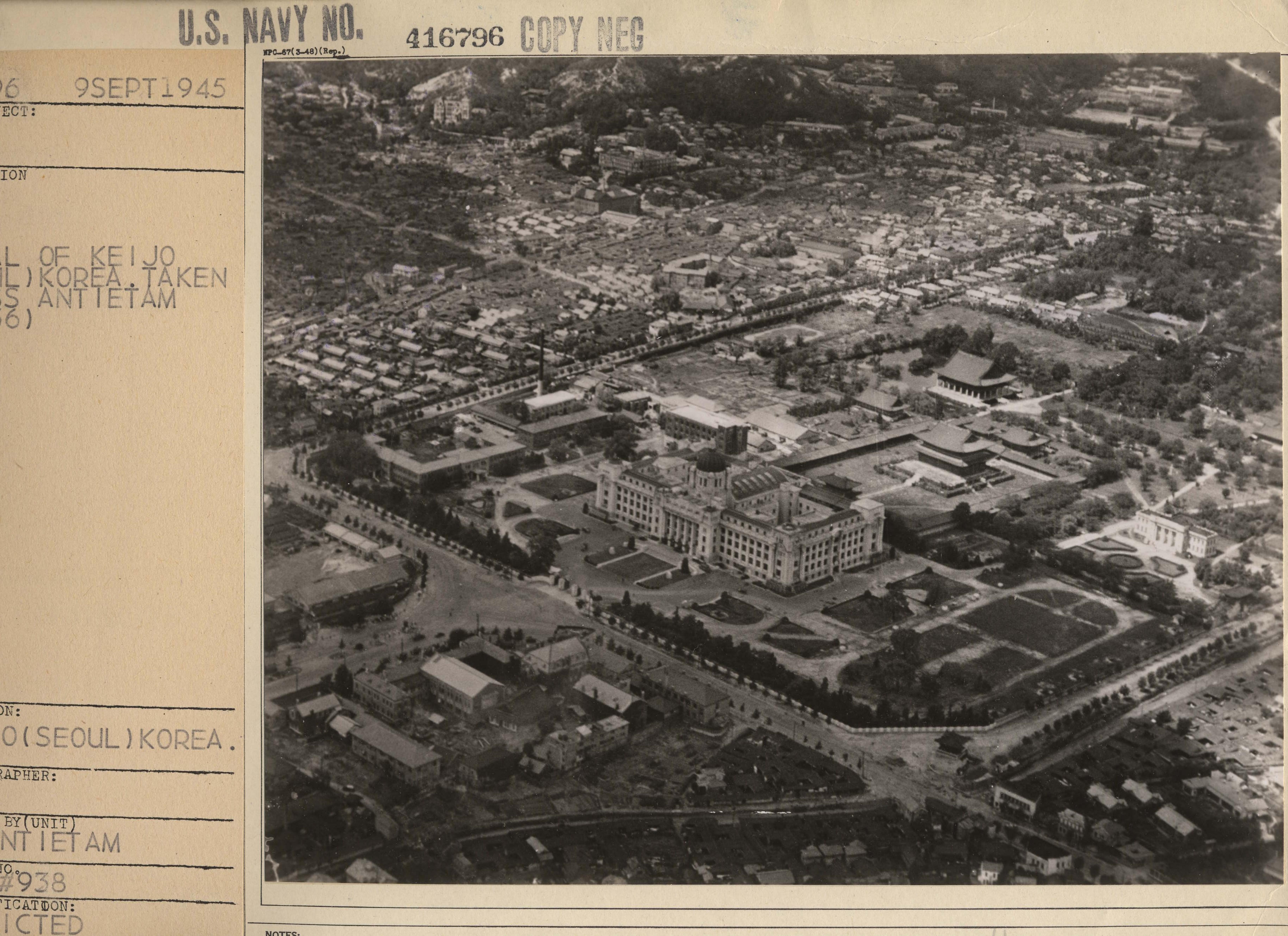
1950 — 1953Gwanghwamun's wooden portions burned completely. Heavy war damage throughout.
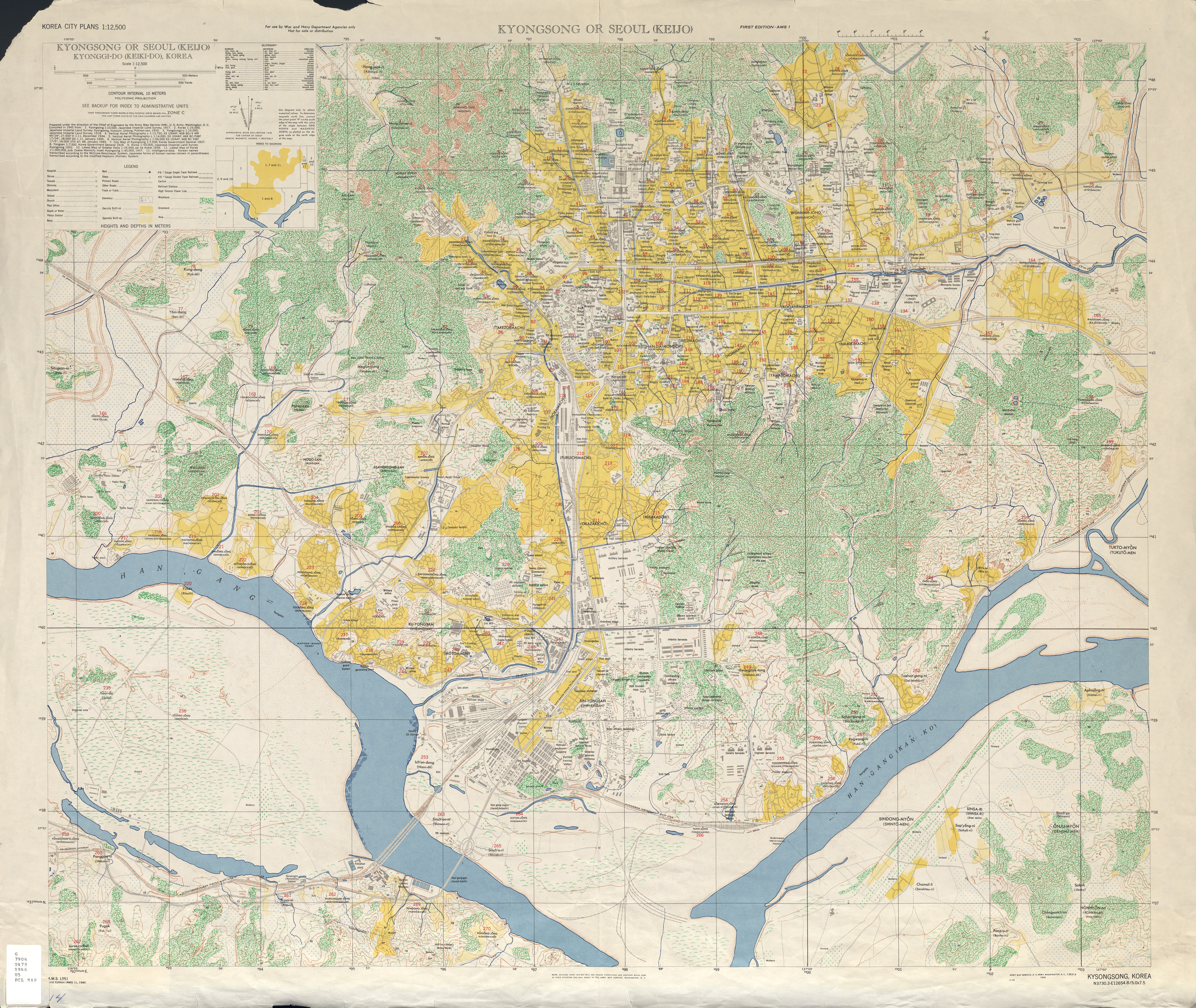
1960s — 1990s1968: Gwanghwamun rebuilt in concrete, facing wrong direction. 16-lane highway. Government-General Building repurposed as National Museum (1986).
1995 — 20101995–96: Government-General Building demolished. 2006–10: Gwanghwamun restored to original position. 2009: Gwanghwamun Square created, lanes reduced to 10.
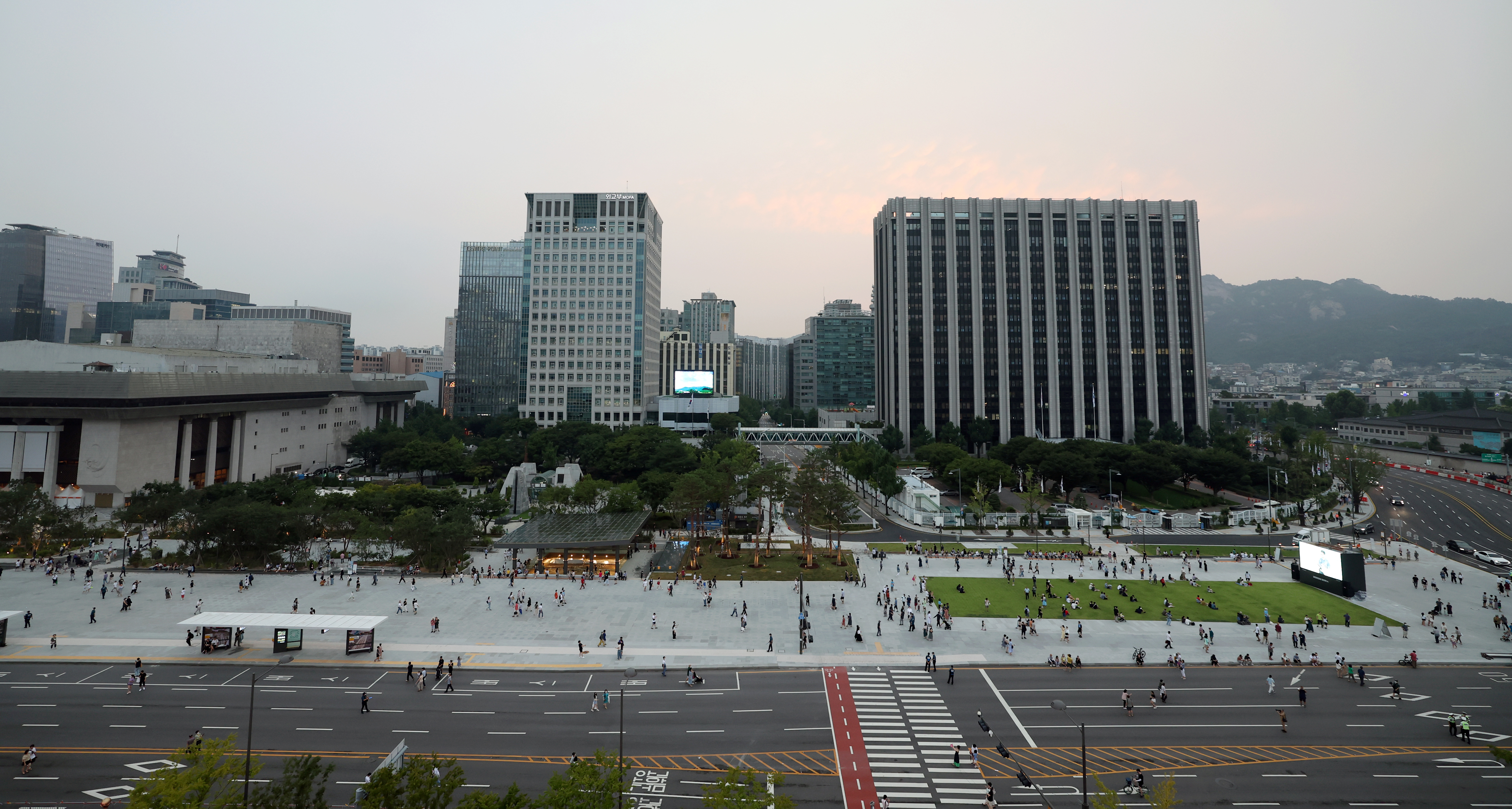
2020 — presentArchaeological excavation uncovered 26 Joseon-era building sites beneath the road. Saheonbu ruins preserved in situ underground. Square expanded 1.7x, road reduced to 6 lanes.

PART III
ERAS
1395 — 1910
Joseon Dynasty
Yukjo Street — Street of Six Ministries
Yukjo Street lined with the Uijeongbu (supreme council), the six ministries, Saheonbu (inspector-general), and Hanseongbu (Seoul prefecture). A narrow traditional street flanked by wooden government buildings under open sky. The street was the political spine of Hanyang — every royal decree, diplomatic procession, and administrative act passed through this corridor between Gwanghwamun Gate and the ministries. Joseon-era maps were not surveys — they were cosmological diagrams. Cartographers like Kim Jeongho (수선전도, c.1840) rendered the capital as a bounded circle of mountains with the palace at its heart, exaggerating peaks to emphasize geomantic power. Government offices were labeled by name and position, not measured by distance. These maps recorded political order, not geographic precision. The Gyeongjo-jeondo and Doseongdo from the Gyujanggak archives at Seoul National University show the same impulse: mapping as an act of statecraft, asserting that the built environment was an extension of cosmological harmony.
Suseonjondo (수선전도) — Kim Jeongho's woodblock map of Seoul, c.1840
Map of Hanyang (Seoul), 1760
Gyeongjo-jeondo (경조전도) — Complete capital map, c.1800
Three Military Divisions of Seoul, 1751 (Gyujanggak, SNU)
Inner districts of Hanseong within the Four Great Gates
Gwanghwamun and Yukjo Street before Japanese alterations, c.1890s
Imperial Palace entrance — postcard, c.1900
Gate of Old Palace — from "Souvenir de Seoul" by Courant, 1900
1910 — 1945
Japanese Colonial
Taihei Boulevard — Erasure and Imposition
Joseon government buildings demolished. The street was widened to 62 meters as Taihei Boulevard (太平通) with tram tracks running its length. The Government-General Building — the largest building in East Asia at its completion — was constructed between 1916 and 1926, placed directly in front of Gyeongbokgung Palace to block the royal axis. Gwanghwamun Gate was physically relocated eastward. The colonial regime used cartography as a tool of spatial domination. The 1912 Keijo Urban Improvement Plan designated 29 road lines for widening — Taihei Boulevard foremost among them. Japanese military surveyors had already produced precise topographic maps of Seoul in 1887, decades before annexation, measuring what they intended to control. The 1910-1918 cadastral surveys at scales of 1:600 to 1:1200 replaced the Joseon land system with Japanese property law, parcel by parcel. By the time the Gyeongseong Sigado was published in 1927, the city had been renamed, resurveyed, and reorganized. Every colonial map of Keijo is simultaneously a geographic document and an instrument of erasure.
Map of Keijo (Seoul), 1913 — Imperial Japanese Govt Railways
Gyeongseong Sigado (경성시가도), 1927 — Government-General map
Map of Keijo (Seoul), c.1930
US Army Map Service — Kyongsong/Seoul, 1946
Government-General Building under construction, 1920
Completed Government-General Building blocking Gyeongbokgung
Gwanghwamun during colonial period — NYPL
Aerial view c.1930 — Government-General Building dominating the palace
1950 — 1953
Korean War
Destruction and Survival
Gwanghwamun's wooden portions burned completely during the fighting. Seoul changed hands four times between 1950 and 1951. The Government-General Building survived as a functional shell — first as the seat of the Republic, then as a target, then as a symbol of contested sovereignty. The corridor that had been the administrative heart of two successive regimes became a war zone. The maps of this era were made by outsiders for military purposes. The US Army Map Service produced the L951 series at 1:12,500, photogrammetric surveys that recorded a city in ruins with clinical precision. The 1946 AMS map bears three names — Kyongsong, Seoul, Keijo — an inadvertent cartographic confession that sovereignty over the city remained unresolved. CORONA spy satellites beginning in 1960 captured Seoul from orbit at 2-8 meter resolution, images that remained classified for decades. What the maps of this era record is absence: the gaps between structures, the missing rooflines, the emptied streets.
Aerial of Seoul, September 1945 — from USS Antietam, weeks after liberation
Aerial view of Gyeongbokgung, 1965 — Park Chung-hee era
Central Government Building during Korean War — October 18, 1950
Government-General Building as Korean Capitol, c.1950
Gwanghwamun from across the street — post-war
1960s — 1990s
Modernization
Concrete and Sixteen Lanes
In 1968, Gwanghwamun was rebuilt in reinforced concrete — facing the wrong direction, rotated 3.5 degrees from its original Joseon alignment. The street became a 16-lane highway, the widest urban arterial in Seoul. In 1986, the Government-General Building was repurposed as the National Museum of Korea. The corridor's identity shifted from political axis to traffic corridor. The sky that had been visible above low wooden rooflines in the Joseon era was now a narrow band between high-rise office blocks. Mapping in the modernization era was functional, not interpretive. Seoul Metropolitan Government aerial surveys began in 1972, producing orthophotos for infrastructure planning. The National Geographic Information Institute (NGII) maintained continuous aerial coverage from the 1960s onward. These maps served the developmental state: they measured roads, plotted utility corridors, and optimized traffic flow. The corridor was no longer a political axis or a colonial showcase — it was a traffic engineering problem.
Sejongno, 2012 — after reduction from 16 to 10 lanes
Government-General Building, 1995 — before demolition
1995 — present
Restoration & Excavation
Unearthing the Layers
In 1995-96, the Government-General Building was demolished in a nationally televised event. Between 2006 and 2010, Gwanghwamun was restored to its original position using traditional materials. In 2009, Gwanghwamun Square was created, reducing traffic lanes from 16 to 10. In 2020-21, archaeological excavation beneath the road uncovered 26 Joseon-era building sites, 4 wall sites, 7 drainage sites, and 5 wells from the Six Ministries. The Saheonbu ruins are now preserved and exhibited in situ underground. The square was expanded 1.7x in 2022, and the road reduced to 6 lanes. The mapping of the restoration era inverts the colonial project: instead of surveying from above to impose new order, excavators map from below to recover what was buried. The Seoul Metropolitan Government's S-MAP 3D digital twin overlays historical maps onto the modern city in georeferenced layers. The Gwanghwamun Square project (gwanghwamun.seoul.go.kr) published its own archaeological cartography — plans of Joseon foundations discovered beneath asphalt, drawn at the same scales as the cadastral surveys that had erased them a century earlier. The city is literally digging through its own layers of imposed and inherited space.
Gwanghwamun Plaza with Yi Sun-sin statue — Bugaksan visible
Gwanghwamun Gate and Bugaksan Mountain, 2018
Renewed Gwanghwamun Square, August 2022 — 1.7x expansion
Gwanghwamun Square — night view, 2024

PART IV
LAYERS
Cartographic Layers
One site, eleven maps
Scroll to traverse time

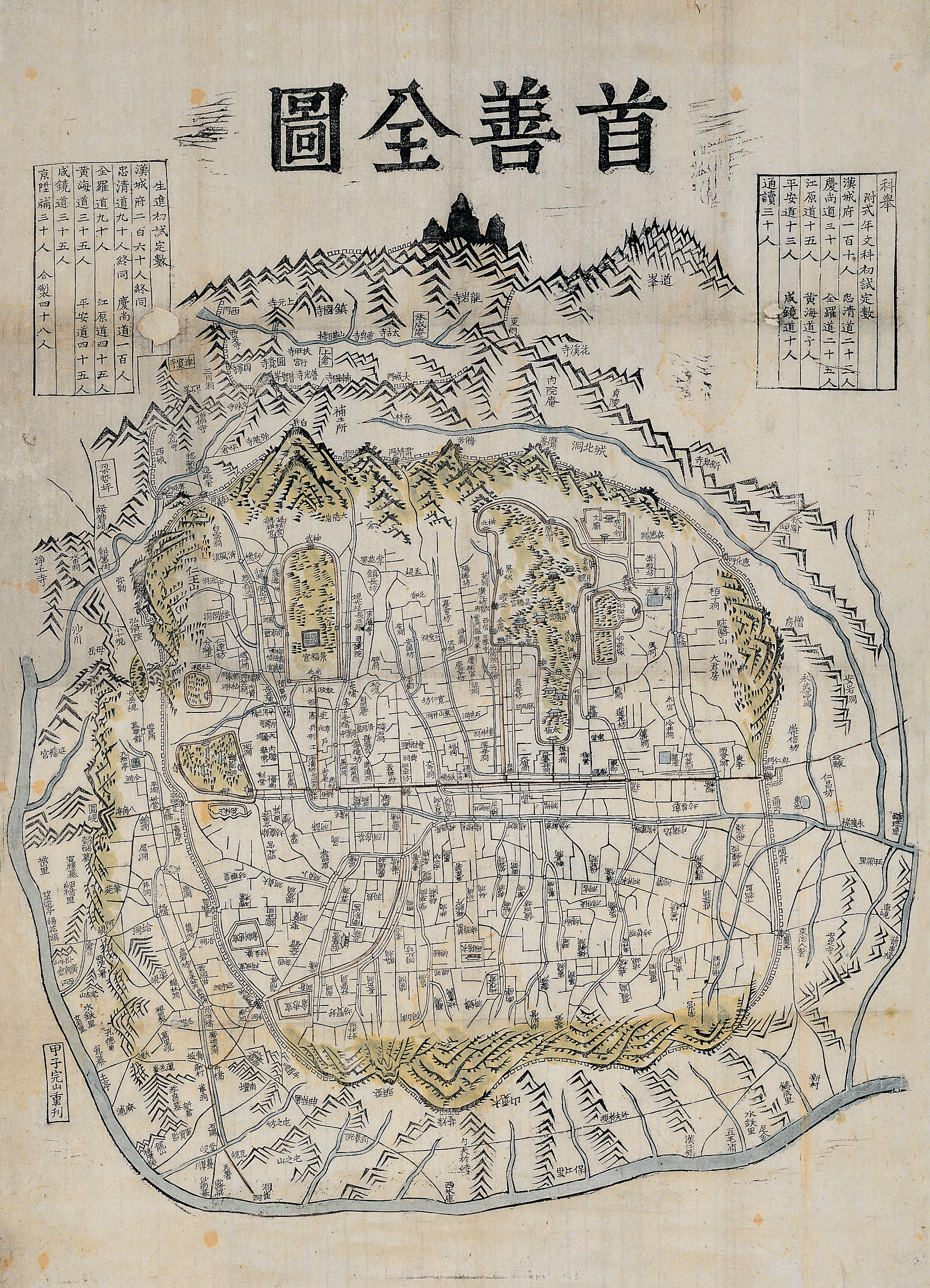
Each map below is cropped to the same geographic area — the ~600m corridor from Gwanghwamun Gate south through Yukjo Street. As you scroll, the view holds steady while the cartographic layer changes beneath it. What shifts is not the vantage point but the regime, the surveyor, the technology, and the intention behind the act of mapping. The same ground, drawn by different hands, for different purposes, across six centuries.
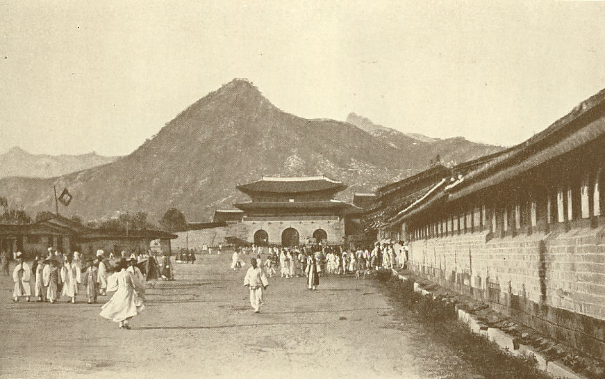
c.1800
Gyeongjo-jeondo (경조전도)
Map — Library of Congress
Complete capital map. Palace compounds outlined in red. Yukjo Street extends south from Gwanghwamun through the Six Ministries quarter — the political spine of Joseon Hanyang.
1 / 11
Gyeongjo-jeondo (경조전도)Suseonjondo (수선전도)Gwanghwamun and Yukjo StreetMap of Keijo (Seoul)Gyeongseong Sigado (경성시가도)Aerial — Gyeongbokgung and Sejong-roAerial — LiberationKyongsong / Seoul / KeijoAerial — GyeongbokgungSejongno — After Lane ReductionGwanghwamun Square — Renewed

PART V
SOURCES
Literary Sources

Isabella Bird BishopKorea and Her Neighbours (1898). Four visits 1894–1897. Seoul streets, palaces, Gwanghwamun area.

Percival LowellChoson, the Land of the Morning Calm (1885). Palace interiors, gates, street life.

Joseon Wangjo Sillok — Annals of the Joseon Dynasty, 1392–1910. 1,893 volumes. Capital street system, royal orders.

Dongguk Yeoji Seungnam — Comprehensive geographical encyclopedia (1481/1530). Hanyang layout, buildings, walls, gates.

Todd A. HenryAssimilating Seoul (UC Press). Colonial public space, focused on this axis. Sejong Prize winner.

Map Archives
ArchiveHoldings
Library of CongressCarpenter, Foulk, Underwood collections; maps from 1760–1946
Seoul History Archive26,131+ items: maps, photos, excavation records
Seoul Photo Archive98,896 photographs, 1950s–1980s
E-Kyujanggak (SNU)220+ types of old Korean maps (~6,000 sheets)
National Archives of KoreaGovernment records, cadastral maps, photographs
Virginia Tech Colonial Seoul GISGeoreferenced 1936/1938 maps with ESRI shapefiles